Convective cells are frequently observed to form in lines that can extend hundreds of kilometers in length and last for many hours. Such organized lines of convection are commonly known as squall lines. Squall lines account for a significant portion of the warm season severe weather events and precipitation over the central and eastern United States.
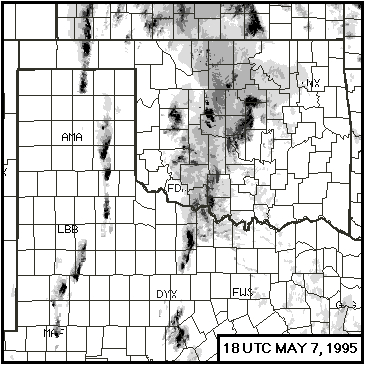
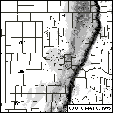
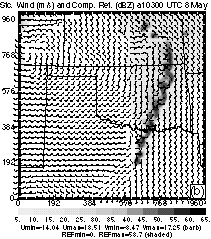
An event involving two intense convective lines occurred on May 7, 1995 over Texas (TX) and Oklahoma (OK). The first relatively weak line organized from initially isolated convective cells developed in northern TX. These cells moved across the border into OK and formed a north-south oriented line in central OK (Fig.1a). To the west, convective storms formed along a clearly defined dryline in the TX panhandle, and quickly organized into a solid squall line. This squall line moved eastward across OK and eventually into Arkansas (Fig.1b), and developed well-organized convective and mesoscale structures typical of classic squall lines.
Using the Advanced Regional Prediction System (ARPS, Xue et al. 1995) and initial condition from the ARPS Data Analysis System (ADAS, Brewster 1996), Wang et al. (1996) were able to simulate the initiation and general evolution of this event reasonably well. However, the detailed timing and location of convection along the lines were less than satisfactory. The initiation of convection associated with the dryline was delayed in the simulation. This paper represents a continued effort in improving the prediction of this event.
2. NUMERICAL EXPERIMENTS
As in the previous simulation study, two one-way nested grids are used here. The horizontal resolutions are 18 and 6 km, respectively. We start the simulations from 1200 UTC, May 7, 1995, when no convection was present along the western dryline while scattered convection was found in north-central TX, which subsequently moved north-northeastward into OK and organized into the eastern line of convection. Given that both lines were initiated in TX where observations were relatively sparse in space (no surface mesonet as in OK) but reasonably frequent in time, significant improvement to the prediction may be achievable through four-dimensional data assimilation (FDDA). FDDA would also reduce the spinup problem observed in previous simulations (Wang et al. 1996), when the model was 'cold started' from an initial analysis that contained only scales larger than the grid could resolve.
While FDDA methods based on variational techniques (e.g., Le Dimet and Talagrand 1986) are theoretically sound, simpler methods based on Newtonian nudging have also proven to be effective in regional models (e.g., Stauffer and Seaman 1990). We choose in this study to use a procedure based on periodic reanalyses of model predictions, which we refer to as the intermittent data assimilation (IDA).
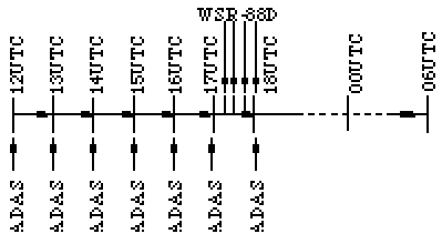
The IDA method is designed to exploit the availability of various data and the successive correction nature of the Bratsech scheme used in the ADAS. With this strategy, the model is integrated forward from an initial analysis for a specified period, a new analysis is then obtained by combining the model prediction with observations of different scales. The cycle is repeated for several times until an assimilated initial condition is obtained. The model is then integrated forward from this condition. Fig. 2 shows a procedure in which conventional observations are assimilated every hour for five hours, then WSR-88D radar data are assimilated every 15 minutes for another hour. The model prediction then starts at 1800 UTC.
We report here results from four experiments (Table 1) on the 6 km grid: EX1 starts from ADAS analysis at 1200 UTC without any reanalysis / assimilation, EX2 and EX3 go through, respectively, three and six hourly reanalysis cycles. These analyses include upper-air soundings, surface observations from AWS and the Oklahoma mesonet stations, and the hourly wind profiler data. EX4 incorporates data from four WSR-88D radars in OK and western TX (KAMA, KLLB, KTLX and KINX), by assimilating radial velocity and reflectivity at 15 minute intervals during the last hour of the assimilation period. A relatively simple radial velocity correction procedure (Brewster 1996) and a semi-empirical method for deriving cloud and rain water contents from reflectivity are used. All experiments end at 0600 UTC, May 8, 1995, 18 hours from the initial time of 1200 UTC.
| Exp. | Data Assimilation | Physics |
| EX1 | Cold start from 12 Z | Warmrain, no API |
| EX2 | Hourly 12-15Z | Warmrain, no API |
| EX3 | Hourly 12-18Z | Ice micro., API |
| EX3a | As EX3, but diff. phy. | Warmrain, no API |
| EX4 | Hourly 12-17Z, every 15 min with radar 17-18Z | Ice micro., API |
3. RESULTS
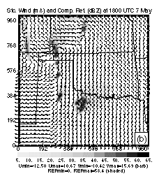
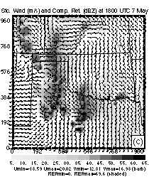
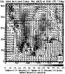
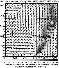
Limited by space, we present here the fine grid results only. Figure 3 shows the model surface winds and reflectivity fields at 1800 UTC, for the four experiments. Note that only fields of EX1 and EX2 are predictions at this time, while the others are assimilated fields.
The most noticeable difference between Fig.3a (EX1) and Fig.3b (EX2) is in the reflectivity in the TX pan-handle area. EX2, with the aid of three reanalyses, generated convective cells along the dryline much in agreement with the observation (Fig.1a), while EX1, being a cold start run, failed to predict any convection in the same area by this time. The latter is due to the fact that observations are sparse in this area and it takes the model a significant time to build up small-scale forcing necessary to trigger convection. The IDA procedure apparently alleviates this 'spinup' problem. EX1 has largely missed the convection in central OK, however.
Figure 3c shows the fields from EX3 at 1800 UTC, in which 3 more assimilation cycles are performed compared to EX2. The reflectivities are stronger and the line more solid. A large part of the differences, however, is due to the use of ice microphysics (c.f., EX3a, not shown), which generates much broader anvils hence wider composite (vertical maximum) reflectivities. A low-level cross-section (not shown) exhibits a pattern more similar to Fig.3b. This experiment also missed the convection in central OK.
Fig.3d shows the fields from EX4. With four assimilations of radar data, the convection in central OK is now successfully captured. A few small convective cells are also seen developing in side the domain. Overall, the atmospheric state at this time is represented very well by these fields. Detailed diagnostic analyses of the initiation of convection along the dryline before 1800 UTC can be found in Xue et al. (1998).
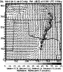
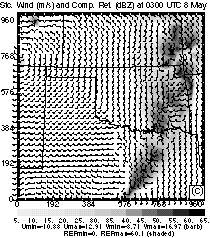
Shown in Fig.4 are fields from the four experiments at 0300 UTC, May 8, 15 hours from the initial time of 1200 UTC, May 7. The reflectivity fields of EX1 and EX2 are similar, and those of EX3 and EX4 are similar, indicating that the IDA procedure does not significantly affect the later evolution of the mature squall line in spite of its significant impact on the early development of convection. The latter two experiments differ from the first two primarily due to their use of ice microphysics. The systems are stronger and the lines propagate faster with ice, consistent with common understanding. The observed trailing stratiform precipitation behind the squall line is much better simulated in the cases using ice (compare Fig.4d with Fig.1b). A detailed analysis of the structure of this major squall line can be found in Wang et al. (1998).
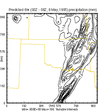
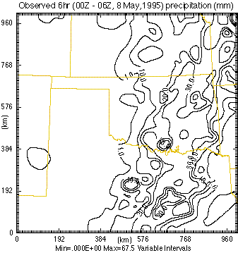
Finally, a comparison between the predicted and observed rainfall between 00 and 0600 UTC, May 8 is given in Fig.5. A reasonable agreement can be found in the precipitation patterns, but the model overpredicts the maximum precipitation by a significant amount. The insufficent horizontal resolution combined with the use of explicit microphysics seems to be the cause.
4. SUMMARY
It is shown that the intermittent data assimilation strategy significantly reduces the spin-up problem associated with cold-start forecast, and improves the prediction, especially during the first a few hours. The inclusion of radar data has the strongest impact on the prediction of convection along the first convective line in central Oklahoma. The model is also able to capture the structure and evolution of the mature squall line and predict the precipitation pattern reasonably well.
5. ACKNOWLEDGMENTS
This research was supported by the NSF grant ATM91-20009 to CAPS, and by a supplementary grant from FAA through NSF. The simulations were made on the Cray C90 of Pittsburgh Supercomputing Center. Many people at CAPS contributed to improvements in the ARPS, which translated to improved simulations reported here.
6. REFERENCES
Benjamin, S. G., and coauthors, 1991: Mon. Wea. Rev., 119, 888-906.
Brewster, K., 1996: Application of a Bratseth analysis scheme including Doppler radar data. Preprints, 15th Conf. on Wea. Analy. and Forecasting, Amer. Meteor. Soc., Norfolk, VA, 92-95.
Le Dimet, F. X., and O. Talagrand, 1986: Variational algorithms for analysis and assimilation of meteorological observations: Theoretical aspects. Tellus, 38A, 97-110.
Stauffer, D. R., and N. L. Seaman, 1990: Mon. Wea. Rev., 118, 1250-1277.
Wang, D., M. Xue, D. Hou, and K. K. Droegemeier, 1998: Midlatitude squall line propagation and structure as numerically simulated by a nonhydrostatic stormscale model. This volume.
Wang, D., M. Xue, V. Wong, and K. K. Droegemeier, 1996: Prediction and simulation of convective storms during VORTEX 95. Preprint, 11th Conf. Num. Wea. Prediction, Amer. Meteor. Soc., Norfolk, VA, 301-303.
Xue, M., K. K. Droegemeier, V. Wong, A. Shapiro, and K. Brewster, 1995: ARPS Version 4.0 User's Guide. 380 pp [Available from CAPS, U. Of Oklahoma].
Xue, M., D.-C. Hou, D.-H. Wang, and K. K. Droegemeier, 1998: Analysis and prediction of convective initiation along a dryline. 16th Conf. Wea. Analy. Forecasting. Amer. Meteor. Soc., Phoenix, Arizona.
It may be argued that all predictions did not start from the same initial time due to the difference in the length of assimilation period. Since the main goal of this paper is to examine the effect of data assimilation on the storm initiation, by including additional observations, the simulation results and the comparisons between them remain instructive.
While relatively strong low-level forcing a long the dryline is evident for the western squall line, the forcing mechanism for the convection along the first (eastern) line is not at all clear.
Benjamin, S. G., K. A. Brewster, R. L. Brummer, B. F. Jewett, T. W. Schlatter, T. L. Smith, and P. A. Stamus, 1991: An isentropic three-hourly data assimilation system using ACARS aircraft observations. Mon. Wea. Rev., 119, 888-906.
Brewster, K., 1996: Application of a Bratseth analysis scheme including Doppler radar data. Preprints, 15th Conference on Weather Analysis and Forecasting. Amer. Meteor. Soc., Norfolk, VA, 92-95.
Le Dimet, F. X., and O. Talagrand, 1986: Variational algorithms for analysis and assimilation of meteorological observations: Theoretical aspects. Tellus, 38A, 97-110.
Stauffer, D. R., and N. L. Seaman, 1990: Use of four-dimensional data assimilation in a limited-area mesoscale model. Part I: Experiments with synoptic-scale data. Mon. Wea. Rev., 118, 1250-1277.
Wang, D., M. Xue, D. Hou, and K. K. Droegemeier, 1998: Midlatitude squall line propagation and structure as numerically simulated by a nonhydrostatic stormscale model. 16th Conf. Wea. Analysis and Forecasting. Amer. Meteor. Soc., Phoenix, Arizona, This volume.
Wang, D., M. Xue, V. Wong, and K. K. Droegemeier, 1996: Prediction and simulation of convective storms during VORTEX 95. Preprint, 11th AMS conference on Num. Wea.r Pre. Amer. Meteor. Soc., Norfolk, VA, 301-303.
Xue, M., K. K. Droegemeier, V. Wong, A. Shapiro, and K. Brewster, 1995: ARPS Version 4.0 User's Guide. Center for Analysis and Prediction of Storms, [Available from CAPS, Univ. of Oklahoma, 100 E. Boyd St., Norman OK 73019], 380 pp.
Xue, M., D.-C. Hou, D.-H. Wang, and K. K. Droegemeier, 1998: Analysis and prediction of convective initiation along a dryline. 16th Conf. Wea. Analy. Forecasting. Amer. Meteor. Soc., Phoenix, Arizona.
Corresponding Author Address: Ming Xue, CAPS,
University of Oklahoma, 100 East Boyd
Norman, OK 73019. E-mail: mxue@ou.edu.